UDDC: Urban Renewal for People’s Well Being and Sustainability
The Urban Design and Development Center (UddC) has expertise in cities under the Center of Excellence in Urban Strategies (CE.US), Chulalongkorn University. It has made a proposal for big-picture provincial urban strategic planning, showing how provinces can adapt to the changing trends of emerging urban cities. One plan for Rayong is to enhance its capacity for international competitiveness and to develop its old town centre. This can be done with a concept of urban renewal through a collaborative planning process, and create a balance between consultation planning and strategic planning with key alliances and stakeholders. This can be done by using scenario planning tools to acquire ideas for regeneration of Rayong’s old town that is ready for the 21st century sustainable development process.
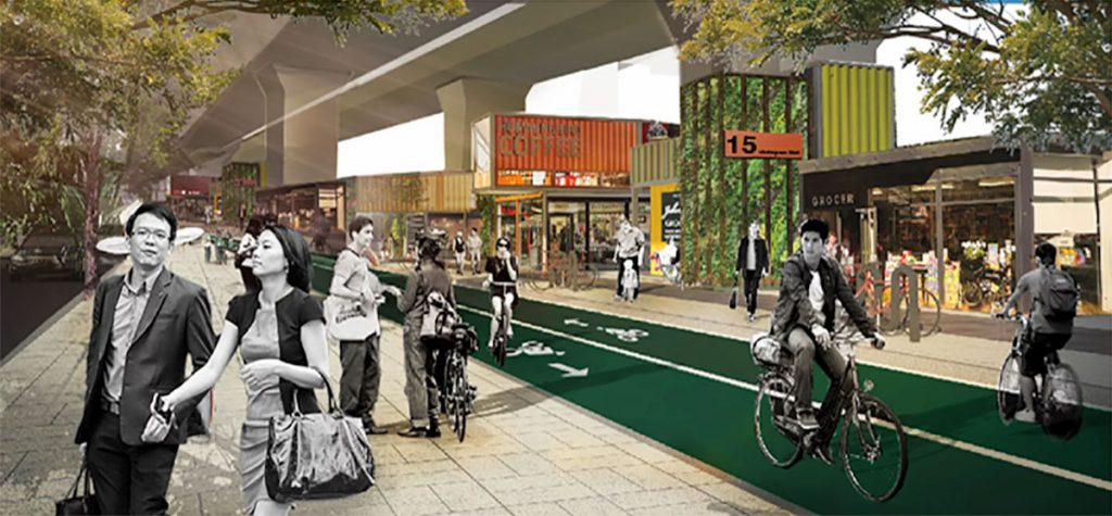
A survey in 2007 showed that about 28,800 hectares of privately owned land (18% of Bangkok areas) are not properly utilized and developed. In addition, there remains some unused state-owned such as 80 hectares in Makkasan, 96 hectares at the Thailand Tobacco Monopoly factory, 400 hectares in Klong Toey, and also over 96 hectares under elevated expressways. All these lands could be regenerated into public spaces. The total land area under Bangkok’s elevated expressways is 252.32 hectares, of which 42.26% (about 106.56 hectares) is undeveloped.
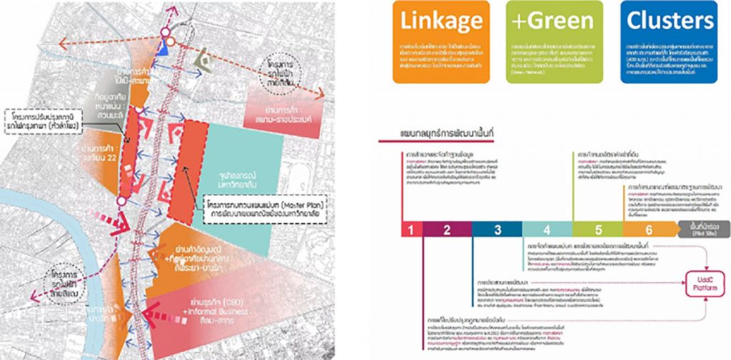
UddC understands that it can transform this crisis into an opportunity by renewing these deserted urban spaces to correspond with the urban context. The urban renewal initiatives can also help boost land use potential of the surrounding areas and maximize benefits for quality land use through three key concepts:
1) Linking together the land under the expressway making it part of the urban landscape, encouraging cycling and walking as alternative methods of commuting downtown.
2) Increasing green spaces in urban areas to help adjust weather conditions and lower local temperatures, reduce traffic pollution and connecting existing urban green spaces to form a green network.
3) Creating spaces for a variety of activities according to the location, which can help support community economies and local social activities, encouraging sustainable community economies.
UddC has the opportunity to develop local Bangkokians’ quality of life in line with the potential of those areas. Spaces in inner Bangkok have several different characteristics; for example Klong San, Talad Noi and China Town are historic and cultural districts, Dusit is a civil service district, Silom is commercial and Sathorn is a significant historic district and also a residential area. Urban renewal planning in each district can help improve residents’ quality of life.
GoodWalk Project: A Development of Public Space to Promote a Better Well-being as a “Health Fund” for People of All Ages.
Bangkok still has a potential for the development of a network for green spaces. This can be designed to improve the wellbeing for urban dwellers. Examples of spaces with potential are derelict structures and undeveloped land under expressways. In downtown areas of Bangkok only, there are about 96 hectares of land twice as big as Lumpini Park that remain unutilized. If the derelict structures and land under expressways were developed as green spaces, this would increase local residents’ opportunities to access into public health amenities.
Asst. Prof. Niramon Serisakul, Director of UddC, has cooperated with the Bangkok Metropolitan Administration (BMA) to develop a project called “GoodWalk” by incorporating the concept of a ‘designable city’, focusing on “ageing-friendly urban design”. This is the standard design for buildings and public spaces worldwide. However, it is also important to design cities for younger residents while also preparing them for an active old age. As a result, an urban design must create “a culture for a good life” to encourage people to build up their health and wellbeing in preparation for a quality old age.
“A Renewal of Lifeless Structures towards New Uses that Serve the Needs of Residents of Both Sides”
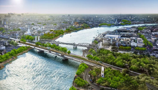
Although many spaces in Bangkok are congested, there remain a few potential spaces that can be designed to help enhance residents’ health and wellbeing. One scheme is the Chao Phraya elevated garden project, which will make use of under-utilized state-owned land including a renewal of old unfinished railway tracks across the Chao Phraya River. It is meant to be used for a green walkway and bicycle route across the Chao Phraya River for all residents and to attract walkers with a scenic view at the park. In addition, the project remains a prototype showing concerted efforts between both central and local government to help renew urban areas, increase urban green spaces and offer public space to sustainably promote better health and wellbeing.
The sky park – a walkway across the Chao Phraya River and Thailand’s first elevated park is a collaboration between UddC and the BMA’s Division of Survey and Mapping, Department of City Planning, BMA; Department of Rural Roads; the Expressway Authority of Thailand was completed in 2020. It was a renovation of the defunct Lavalin Electric Railway. The original construction was never completed, and the space has not been used for more than 30 years. The redevelopment of this was proposed by development partners who joined a workshop meeting for the Bangkok 250’s Phase 1 to be one of the pilot projects of the Kadeejeen- Khlongsan Restoration Master Plan. As the coordination focal point, UddC works with multi-sectoral agencies for the cooperation between the BMA Office of Town Planning, the Department of Rural Roads and the Harbor Department of the Ministry of Transport to make the defunct railway into a walkway and bicycle route across the Chao Phraya River, linking traffic between the Thonburi and Rattanakosin sides.
UddC has developed the design concept by organizing a multi-level participation process for both the private and public sectors, including the use of a mechanism to drive the so-called home-temple-school-government (Baw-Waw-Raw) through a discussion process with its stakeholders and coordination with agencies concerned. This is to create a consensus design agreed by all parties involved, including benefits for the community and wider public under the key objectives as follows:
1) Creating an alternative for traveling across the river by foot and bicycle to improve urban health and quality of life;
2) Creating benefits for all sectors, including the general public, local communities, tourists, and especially the students in the 25 schools and universities located around the two banks of the river;
3) Promoting a cultural tourism network with the historic neighborhoods on both the Rattanakosin and Thonburi areas, especially a linkage of continuous commuting routes via the canals around the city. In addition, UddC has formed design collaborations with Land Process, N7A and the Lighting Research and Innovation Center of the King Mongkut’s Institute of Technology, Thonburi Campus. These partnerships can help reconstruct the identity of the bridge to make it friendly with commuters and also increase green spaces in the park by connecting the route on the way up and down for the surrounding neighborhoods. As a result there will be more shade and the park can serve as a convenient place to relax day to day. At the same time, there is a light design to ensure user safety in the evenings, and to promote the park to become a new riverside destination of the Chao Phraya River.
BY
Urban Design and Development Center
Faculty of Architecture, Chulalongkorn University
Related articles:
Others